
As of Saturday afternoon, the NWS Storm Prediction Center maintained the same outlook for severe weather on Sunday. While still enhanced in the Baton Rouge area, the greatest risk remains north of the I-10/12 corridor.
Through Tonight: A mostly sunny Saturday afternoon will give way to increasing clouds overnight. After high temperatures in the upper 70s, low temperatures will stay in the 70s as warmer and more humid air surges in from the Gulf of Mexico. This will set the stage for an active round of weather on Sunday.
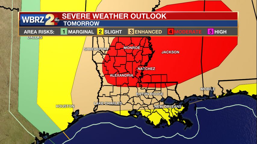
Sunday: An upper level wave and associated cold front will move into the area on Sunday with rain and possibly severe thunderstorms. The Storm Prediction Center is using bolder language than usual saying “an outbreak of severe thunderstorms appears likely” on Sunday. The day two outlook places areas north of I-12 in an unusual 4/5 “moderate risk” with areas around Baton Rouge in a 3/5 “enhanced risk” and coastal areas in a 2/5 "slight risk" for severe weather. Everything from damaging wind gusts to hail to tornadoes will be possible. Activity is expected to begin during the late morning hours and intensify through the afternoon. Regardless of severe weather, winds are expected to be gusty through the day with 20 to 30mph sustained winds and gusts over 40mph. Secure loose objects before going to be on Saturday.
*WIND ADVISORY* for the shaded area. Gusts may top 40mph. The latest winds --> https://t.co/8dsSPuGqVa #WBRZwx pic.twitter.com/K5Z2UXS8Zo
— WBRZ Weather (@WBRZweather) April 11, 2020
By Sunday evening, the strongest storms will depart eastward. In this time of staying home with loved ones, now is a great opportunity to identify or review your severe weather plan. Find the lowest and most interior place in your home to use as a safe place if a warning is issued. Mobile Home residents should find a nearby brick and mortar home of a family member or friend as it is recommended you prioritize the near term weather threat over social distancing. CLICK HERE for some ideas. Quiet weather and below average temperatures will persist Monday through Wednesday.
Faced with severe weather on Sunday, #SocialDistancing or #TornadoSafety? Act on the more immediate danger. If a tornado watch is issued, we recommend mobile home residents seek sturdy shelter with friends or family. Wear a mask and gloves if possible. pic.twitter.com/wkZ4QOJ0L7
— Josh Eachus (@DrJoshWX) April 9, 2020
Many severe weather threats, and this one is no different, are conditional. While the meteorological formula is there, a few caveats exist that could squash the threat. Some warm air aloft will create stability that could potentially stop significant development. At this time, it is expected that the instability from the surface will overcome this layer, which is why the threat continues. Second, the most favorable ingredients are expected north of Baton Rouge across southwest Mississippi. In past events we have seen the local area serve as the "breeding ground" for storms and they ramp up in intensity as they move northeast into Mississippi. It is possible that scenario plays out again. However, the ingredients across the I-10/12 corridor are much greater than they have been in recent memory. This is added to say the forecast is not a lock but by no means should you let your guard down or stop preparations. The WBRZ Weather Team will monitor the forecast and immediately pass along changes to the outlooks as well as watches and warnings if they are issued.
Monday and Beyond: Once the cold front sweeps through by Monday morning, quiet weather will persist through much of the week. Monday will be mild before a reinforcing front flings a few showers across the area on Tuesday. That front will deliver below average temperatures and lows could dip into the 40s on both Wednesday and Thursday.
Get the latest on News 2, wbrz.com, and the WBRZ WX App. on Apple and Android devices. Follow WBRZ Weather on Facebook and Twitter for even more weather updates while you are on the go.
"severe" - Google News
April 12, 2020 at 01:22AM
https://ift.tt/2Xu6xIA
Continued threat for severe weather on Easter - WBRZ
"severe" - Google News
https://ift.tt/2OrY17E
Shoes Man Tutorial
Pos News Update
Meme Update
Korean Entertainment News
Japan News Update
Bagikan Berita Ini


0 Response to "Continued threat for severe weather on Easter - WBRZ"
Post a Comment