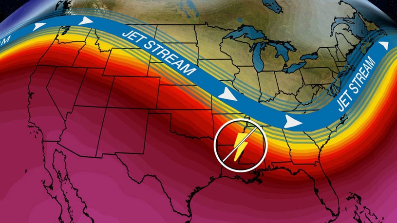
- The jet stream's configuration across the U.S. will undergo a change by next week.
- This pattern change will cause the West to heat up while the East stays cool.
- It will also put an end to the recent parade of severe weather outbreaks in the South.
A change in the weather pattern will take shape across the United States by next week, heating up the West, keeping the East cool, and putting an end to the recent parade of severe weather outbreaks in the South.
The jet stream will reconfigure itself into a large northward bulge, or ridge of high pressure, over the western U.S., with a broad southward dip, or trough of low pressure, over the eastern states. For most of April, that ridge of high pressure was situated over the Gulf of Alaska, but it will move into the western Lower 48 by next week.
Temperatures tend to warm up when the jet stream bulges northward, so some parts of the West could have their warmest air so far this year. Meanwhile, a southward dip of the jet stream typically causes a drop in temperatures, so it will be rather cool in the East next week.
Although some scattered thunderstorms remain possible in the South next week, there will be fewer severe thunderstorms overall.
This pattern change is great news for the South, which has been struck by multiple severe weather outbreaks since Easter and has another round of stormy weather coming this week.
(MORE: Severe Storm and Heavy Rain Threats Return to the South Midweek)
By Sunday, cooler, drier air should push into the South, shutting off the threat of severe weather for a couple of days.
Even with a threat of thunderstorms returning next Tuesday, the setup isn't favorable for tornadoes or an outbreak of severe thunderstorms to the extent we've seen recently.
Temperatures in the parts of Great Lakes and East will be up to 15 degrees below average early next week, as the West warms up to 10 to 15 degrees above average.
Forecast Highs Compared to Average
Warmth is expected to start building in the West as early as late this week. The National Weather Service office in Los Angeles is expecting "a taste of summer with a heat wave" beginning Thursday and lasting through the weekend.
Downtown Los Angeles is predicted to reach 90 degrees for the first time since Nov. 18, with the best chances on Friday and Saturday. This is later than the average date of the first 90-degree day in L.A. of April 15.
Additionally, Phoenix might record its first 90-degree day of the year this Wednesday, more than three weeks later than the average of March 31. By Friday or this weekend, the first 100-degree day of the year is likely. The first 100-degree day has occurred within seven days of the first 90-degree day in Phoenix only four other times on record, according to the NWS.
The latest 6- to 10-day temperature outlook from NOAA's Climate Prediction Center highlights the West, especially areas from California to the Great Basin and Southwest, as having the highest odds of above-average temperatures next week. The interior Northeast, Ohio Valley and Appalachians have the highest odds of below-average temperatures.
Long-Range Temperature Outlook
(This outlook from NOAA's Climate Prediction Center shows the probabilities of above (tan, orange and red contours) or below (blue contours) average temperatures in the period specified.)Some longer-range model guidance suggests this warm West, cool East pattern might persist into at least early May.
The Weather Company’s primary journalistic mission is to report on breaking weather news, the environment and the importance of science to our lives. This story does not necessarily represent the position of our parent company, IBM.
"severe" - Google News
April 21, 2020 at 05:52PM
https://ift.tt/2wVnOzH
Pattern Change Next Week to End Severe Weather Outbreak Parade as West Warms Up and East Stays Cool - The Weather Channel
"severe" - Google News
https://ift.tt/2OrY17E
Shoes Man Tutorial
Pos News Update
Meme Update
Korean Entertainment News
Japan News Update
Bagikan Berita Ini


0 Response to "Pattern Change Next Week to End Severe Weather Outbreak Parade as West Warms Up and East Stays Cool - The Weather Channel"
Post a Comment