
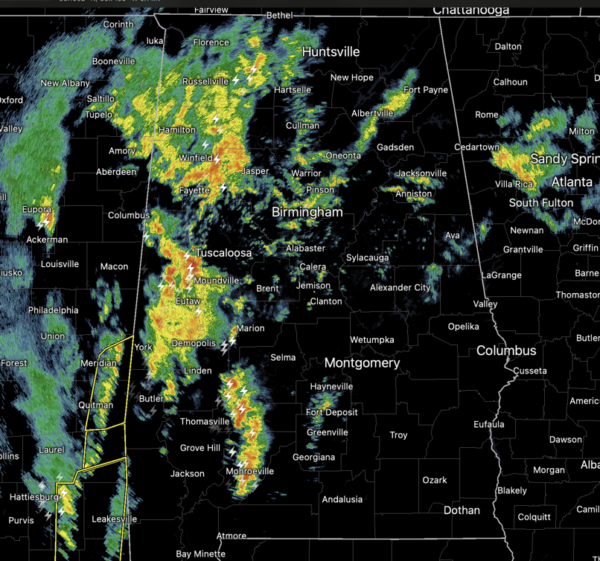
Widespread rain and some storms are ongoing across Alabama again today and these will continue through the afternoon and evening hours. The rain will be heavy at times, and the flood watch remains in effect for the northern two-thirds of Alabama. We will continue to see some flooding issues in the coming days with the persistent have rainfall. We note additional rain amounts between now and Saturday evening across Alabama will be in the 2-4 inch range. Temperatures are above average today through Saturday with highs in the upper 60s to mid 70s.
A few strong thunderstorms are also possible today, the SPC has increased the threat level to “slight risk” (level 2/5) of severe thunderstorms for out southwestern continues, south and west of a of line from Tuscaloosa to Selma to Monroeville and the “marginal risk” for basically the rest of Alabama through tonight.
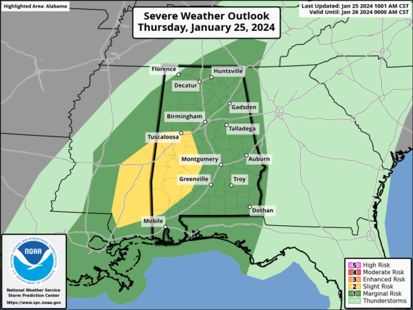
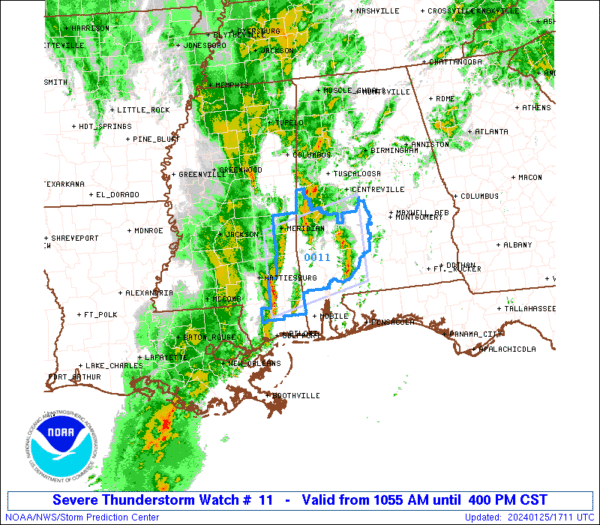
Stronger storms later today will be capable of producing strong, gusty winds. A few tornadoes are possible, mainly across the the “slight risk” areas. The main window for stronger thunderstorms will come through the afternoon and evening hours. Remain weather aware later today. A severe thunderstorm watch has been issued for portions of Southwest Alabama until 4PM.
SATURDAY STORM THREAT: Saturday will be a mild and breezy day and another wave of energy will move across Alabama. Strong storms are possible statewide and the SPC has a “slight risk” (level 2 of 5) for severe storms Saturday for much of Central and East Alabama, with a “marginal risk” (level 1 of 5) for much of the rest of the state.
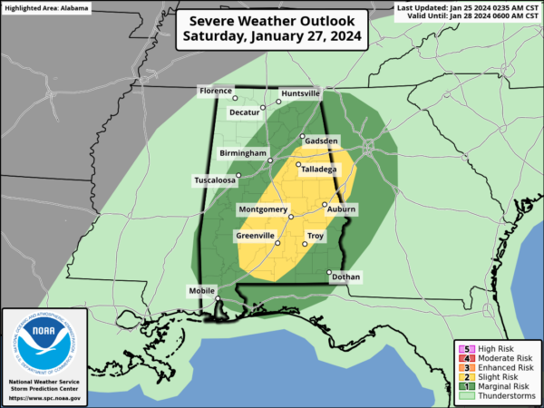
An organized line of strong thunderstorms is expected to develop over East and South Alabama… wind damage would be possible along the leading edge of this line, mainly during the mid to late afternoon. Like today, the risk of a tornado is low, but not zero. The main limiting factor in the severe weather threat Saturday is the lack of surface based instability. Expect highs near 70° on Saturday.
SUNDAY AND NEXT WEEK: Cooler and drier air returns to Alabama on Sunday, with a partly sunny sky along with highs in the 50s and some lingering light rain is possible Sunday. For now the first half of next week looks dry with highs mostly in the 50s and 60s, while lows will be in the 30s and 40s. Some showers could return by midweek.
BEACH FORECAST CENTER: Get the latest weather and rip current forecasts for the beaches from Fort Morgan to Panama City on our Beach Forecast Center page. There, you can select the forecast of the region that you are interested in visiting.
WORLD TEMPERATURE EXTREMES: Over the last 24 hours, the highest observation outside the U.S. was 120.9F at Birdsville Airport, Australia. The lowest observation was -68.3F at Summit, Greenland.
CONTIGUOUS TEMPERATURE EXTREMES: Over the last 24 hours, the highest observation was 84F at Sarasota, Venice, Punta Gorda, and Marco Island, FL. The lowest observation was 1F at Crosby, ND.
Category: Alabama's Weather, ALL POSTS, Severe Weather
"severe" - Google News
January 26, 2024 at 03:05AM
https://ift.tt/XdYQUFk
Midday Nowcast: More Rain and Some Severe Storms Today - alabamawx.com
"severe" - Google News
https://ift.tt/TudIy0N
Shoes Man Tutorial
Pos News Update
Meme Update
Korean Entertainment News
Japan News Update
Bagikan Berita Ini


0 Response to "Midday Nowcast: More Rain and Some Severe Storms Today - alabamawx.com"
Post a Comment