- Severe thunderstorms are possible the next several days in parts of the Southeast.
- Late Friday into Saturday morning may see the most severe storms from north Florida to the Carolinas.
- Damaging winds and tornadoes are possible.
- Heavy rain may trigger flooding, even in drought areas recently affected by wildfires.
Severe thunderstorms, including a threat of tornadoes, and flooding rain will hammer parts of the Southeast in multiple rounds through Saturday.
We’ve already seen some severe weather near the Gulf Coast this week.
An EF1 tornado damaged at least one vehicle and several buildings Wednesday morning in Barbour County, Alabama, southeast of Montgomery.
Damage was also reported in Belleville, Alabama, and another tornado sent forecasters at the National Weather Service scrambling for shelter in Mobile, Alabama, early Wednesday morning.
Unfortunately, there’s more rough weather ahead.
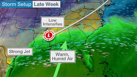
Warm and humid air feeding in from the Gulf of Mexico near a waffling frontal boundary with impulses of the jet stream riding overhead will trigger scattered strong to severe thunderstorms and heavy rain from parts of the northern Gulf Coast to the eastern Carolinas through the day Friday.
Beginning Friday night, though, severe thunderstorms may become more numerous.
That’s because a strong jet stream will cause low pressure in the Southeast to intensify, eventually becoming a bomb cyclone in the Northeast U.S. later Saturday.
(FORECAST: East Coast Bomb Cyclone After Snow Blankets South, Midwest)

This will drive a strong cold front slicing through the warm and humid Southeast, igniting severe thunderstorms ahead of the front from the northern Gulf Coast Friday to the Southeast coast Friday night and Saturday.

Friday and Friday Night's Severe Thunderstorm Forecast
(Shaded on the map above is the likelihood of severe thunderstorms, according to NOAA's Storm Prediction Center. Note that not all categories apply for the severe weather risk on a particular day.)Damaging wind gusts and tornadoes are possible in these severe thunderstorms.
Flash flooding is also a threat.
Over 3 inches of additional rain is expected in parts of north Florida and south Georgia through Saturday.

Rain Forecast
(This should be interpreted as a broad outlook of where the heaviest rain may fall. Locally higher amounts may occur where bands of rain stall over a period of a few hours. Areas of forecast snow accumulation are in white. )Even though parts of the Gulf Coast have slipped into a drought, this rain could eventually trigger flash flooding in some spots, especially where bands of rain and thunderstorms stall for a few hours.
One bit of good news is this soaking rain should drench any wildfires that may still be burning in the Florida Panhandle.
Given the overnight severe weather threat, make sure you have multiple ways of receiving severe, tornado and flash flood warnings from the National Weather Service.
This includes smartphone apps such as The Weather Channel for Android and iOS, and NOAA weather radio, each of which can alert and wake you at night in case of a warning.
(MORE: 9 Severe Weather Safety Tips That Could Save Your Life)
The Weather Company’s primary journalistic mission is to report on breaking weather news, the environment and the importance of science to our lives. This story does not necessarily represent the position of our parent company, IBM.
"severe" - Google News
March 10, 2022 at 05:54AM
https://ift.tt/Kl0qv1k
Severe Thunderstorms, Tornadoes, Flooding Rain Possible Through Saturday in the Southeast | The Weather Channel - Articles from The Weather Channel | weather.com - The Weather Channel
"severe" - Google News
https://ift.tt/5Seyrfn
Shoes Man Tutorial
Pos News Update
Meme Update
Korean Entertainment News
Japan News Update
Bagikan Berita Ini


0 Response to "Severe Thunderstorms, Tornadoes, Flooding Rain Possible Through Saturday in the Southeast | The Weather Channel - Articles from The Weather Channel | weather.com - The Weather Channel"
Post a Comment