Updated: 9:05 a.m.
Minnesota sees very active weather Friday with widespread showers and storms across the state, including areas of severe weather and heavy rain. Much quieter weather returns over the weekend.
Friday’s forecast
Friday morning started warm and muggy, with most of the state in the 60s and 70s. It stays warm and humid into the afternoon, with highs in the 80s and a heat index above 90 for portions of southeastern Minnesota, including the Twin Cities.

Friday high temperatures
National Weather Service
The exception to the temperatures in northwestern Minnesota, which will already feel the cooler air behind a cold front and stays in the 70s.
That strong cold front is a major factor in the Minnesota forecast Friday. Ahead of it, there was already an area of severe weather that impacted northern Minnesota Thursday evening into the overnight. As of 9 a.m., what is left of that storm area is sitting almost stationary over central Minnesota:

8:38 a.m. Friday radar
National Weather Service
The area has weakened, so the morning severe threat is isolated, but heavy, persistent rain is causing areas of flash flooding, especially in west-central Minnesota. That area of showers and storms diminishes through the morning and sags slightly south, bringing even the Twin Cities slight changes for a few isolated morning storms or showers.
Then in the afternoon, as the cold front starts crossing the state, and fueled in part by afternoon heating, severe storms develop and track east across the state.
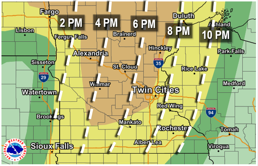
Here is the current timing estimate for the severe storms:

Timing of severe weather Friday
National Weather Service
The entire state is under the severe weather risk, with the areas highlighted in yellow on the map above likely to see scattered storms, and the brown shaded areas showing an “enhanced” risk, which means storms could be more numerous. Damaging winds are the primary threat, but some large hail is also likely along with isolated tornadoes. Heavy rain and localized flooding also remain a concern, and it looks like the heaviest rain will target northern Minnesota.

Rainfall forecast through Friday night
Pivotal Weather
Here are some resources to track storms as they develop Friday:
Weekend forecast
Most of the storms clear the state by late Friday evening as the front moves out, leaving cooler quieter weather behind it. A disturbance moving across northern Minnesota likely brings a few more showers and storms Saturday afternoon and evening, but that round of wet weather only brings an isolated chance for strong storms.

Forecast precipitation Saturday night
Tropical Tidbits

Twin Cities forecast through Tuesday
Weather.us
Otherwise, sunshine returns and the state remains predominantly dry through the weekend and until at least the middle of next week.
Cooler, less humid air also filters across the state behind Friday’s cold front, putting highs across the state mostly in the 70s and low 80s through the start of next week.
Here is the extended forecast for the Twin Cities, showing the quieter weather trend:
Programming note
You can hear my live weather updates on Minnesota Public Radio at 7:48 a.m. Monday through Friday morning.
"severe" - Google News
August 14, 2020 at 07:16PM
https://ift.tt/3kDQAsu
Widespread severe weather expected Friday - Minnesota Public Radio News
"severe" - Google News
https://ift.tt/2OrY17E
Shoes Man Tutorial
Pos News Update
Meme Update
Korean Entertainment News
Japan News Update
Bagikan Berita Ini


0 Response to "Widespread severe weather expected Friday - Minnesota Public Radio News"
Post a Comment