
More than 30 million people are under the threat of severe weather Friday from Texas to Alabama. Another 20 million will be impacted Saturday as the severe threat shifts east into the Carolinas, Georgia and Florida.
"A complex low pressure system will begin to bring a threat of heavy rain and severe thunderstorms across the Deep South on Friday," the Weather Prediction Center (WPC) says. "The unstable airmass will promote the development of heavy rain and severe thunderstorms which will likely expand eastward across the Deep South late Friday into early Saturday."
On Friday afternoon and evening, the greatest threat for severe weather exists for Houston, Dallas, Oklahoma City and Shreveport, Louisiana. As these storms spread from the southern Plains into the lower Mississippi Valley, large hail, damaging winds and isolated tornadoes all appear possible.
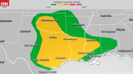
For the north-central Texas area, the greatest threat for widespread severe storms will be in the latter half of the day.
"Any thunderstorms which develop in the morning are expected to remain isolated in nature, but coverage should increase rapidly around or shortly after midday," the National Weather Service (NWS) office in Dallas-Fort Worth says.
While tornadoes are possible Friday, the biggest threat for tornadoes is yet to come.
Shifting east on Saturday
For many southeastern states, the main focus is on Saturday. The main threats exist from New Orleans all the way to Wilmington, North Carolina.
"Main points of uncertainty with the severe threat early Saturday revolve around how fast the warm front moves inland, which will determine how the severe weather threat evolves northwards into the afternoon," according to the NWS in Tallahassee. "Regardless, folks should be prepared for the potential for severe weather for most of Saturday."
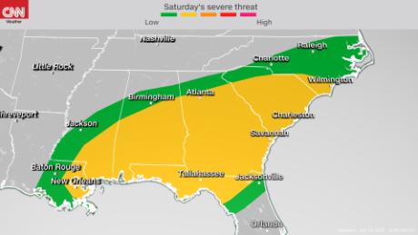
The better threat for Georgia will be along and south of interstates 20 and 85 -- basically metro Atlanta and southeastward through the state.
"A lot of that is going to depend on where the surface low moves and how far north the warm front gets," said Matt Sena, meteorologist for the NWS in Atlanta. "The primary threat is going to be damaging winds. There will be some threat for hail. There is enough shear, so we can't rule out the possibility of tornadoes, but the primary threat will be damaging winds."
While this is a fairly fast-moving system, there will also be a lot of moisture available, which means localized flash flooding will also be possible across the entire Southeast.
This is not welcome news for New Orleans or Baton Rouge, which are dealing with an excess of rain this month. New Orleans, for example, has already picked up over a foot of rainfall in April -- more than 9 inches above normal.
Other cities like Atlanta and Macon in Georgia and Columbia in South Carolina are below average for rainfall for April and could use some rain, but not necessarily with the severe impacts added in.
Additional threat next week
Weather models are also starting to show the potential for additional severe weather next week, mainly Tuesday and Wednesday. In fact, there has been consistent enough guidance suggesting this new system next week could be a more substantial severe threat across the southern Plains, and perhaps the first big event for this region so far this year.
"Most of the significant severe weather days so far this year have been focused on the lower Mississippi Valley and the Deep South," said Taylor Ward, CNN meteorologist. "This could be the most substantial threat of the year so far in Oklahoma and Kansas. While this may be a bit late in the spring, this is certainly not unusual, as late April and May is the peak for severe weather in the Southern Plains."
Rich Gulf moisture is expected to surge northward, meeting up with dry, warm air in Texas and Oklahoma as a trough ejects across the Plains.
"If this occurs, then an organized severe thunderstorm threat will develop, with all severe hazards possible," the Storm Prediction Center warns.
Right now, the greatest threat for severe storms early next week appears to be for north-central Texas, Oklahoma and Kansas.
"Expect adjustments to this area in the coming days, including the potential for greater severe probabilities, as additional model guidance comes in," said the Storm Prediction Center.
"severe" - Google News
April 23, 2021 at 12:43AM
https://ift.tt/3ax7Yfj
Severe storms this weekend are just the beginning of a very active week of weather - CNN
"severe" - Google News
https://ift.tt/2OrY17E
Shoes Man Tutorial
Pos News Update
Meme Update
Korean Entertainment News
Japan News Update
Bagikan Berita Ini


0 Response to "Severe storms this weekend are just the beginning of a very active week of weather - CNN"
Post a Comment