

As of 2:05 pm, thunderstorms continue to east-southeastward across Central Alabama putting down copious amounts of rainfall along with producing gusty winds at times. There are no severe weather warnings in effect at this time, but there are a few Flash Flood Warnings in effect along the I-20 corridor in the central and east-central parts of the area. Flash flooding will continue to be a major threat as these storms are training over the same locations.
Back to our west, we see the second wave of storms has formed into a QLCS back over the western half of Mississippi and is heading in our direction. Nearly the entire line has Severe Thunderstorm Warnings in effect on it at this time. There are a few cells out ahead of that line, one of which had a Tornado Warning in effect but just recently was allowed to expire.
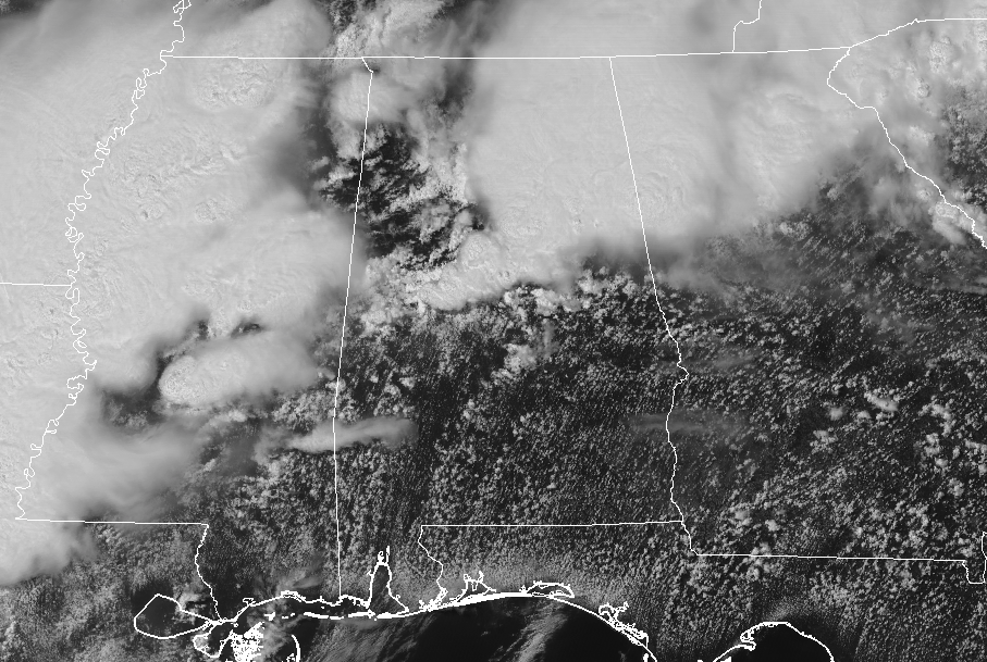
We are seeing breaks in the clouds in between the storms over portions of North/Central Alabama to the storms that are firing up over portions of Mississippi, which will allow the atmosphere to recover somewhat before those storms arrive in our area.
For now, surface-based instability is below 500 J/kg over the North Alabama counties, but quickly rises as you move southward across Central Alabama, reaching around 4,000 J/kg in the extreme southwestern parts of the area. Shear values are higher over the northern half of the area ranging from 40 knots around the I-20 corridor to 60 knots up in the extreme northwestern corner of North Alabama. Helicity values from the surface to the 3-kilometer level are running from 150-250 m2/s2.
As of now, the Significant Tornado Parameter is holding around 1.0. Right now, damaging wind gusts and large hail are the main threats, while we continue to have a smaller threat of a brief tornado or two.
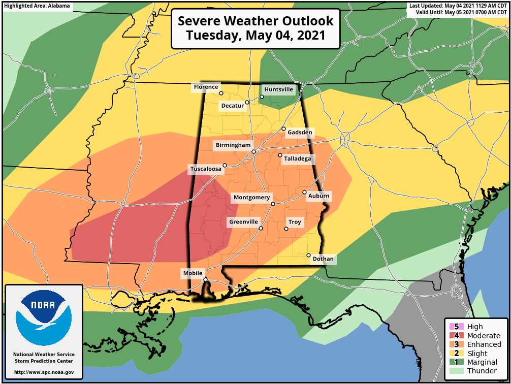
A level 4/5 Moderate Risk continues for the southwestern portions of the area, which includes the cities of Livingston, Demopolis, and Eutaw.
A level 3/5 Enhanced Risk continues for nearly the rest of Central Alabama, including the cities of Tuscaloosa, Birmingham, Clanton, Selma, Anniston, Talladega, Alexander City, Auburn, Montgomery, and Troy.
A level 2/5 Slight Risk continues for the remainder of Central Alabama and most of North Alabama, including the cities of Eufaula, Hamilton, Gadsden, Florence, Russellville, Decatur, Athens, Hartselle, Cullman, Guntersville, and Rainsville.
A level 1/5 Marginal Risk continues for the northeastern parts of North Alabama, including the cities of Huntsville and Scottsboro.
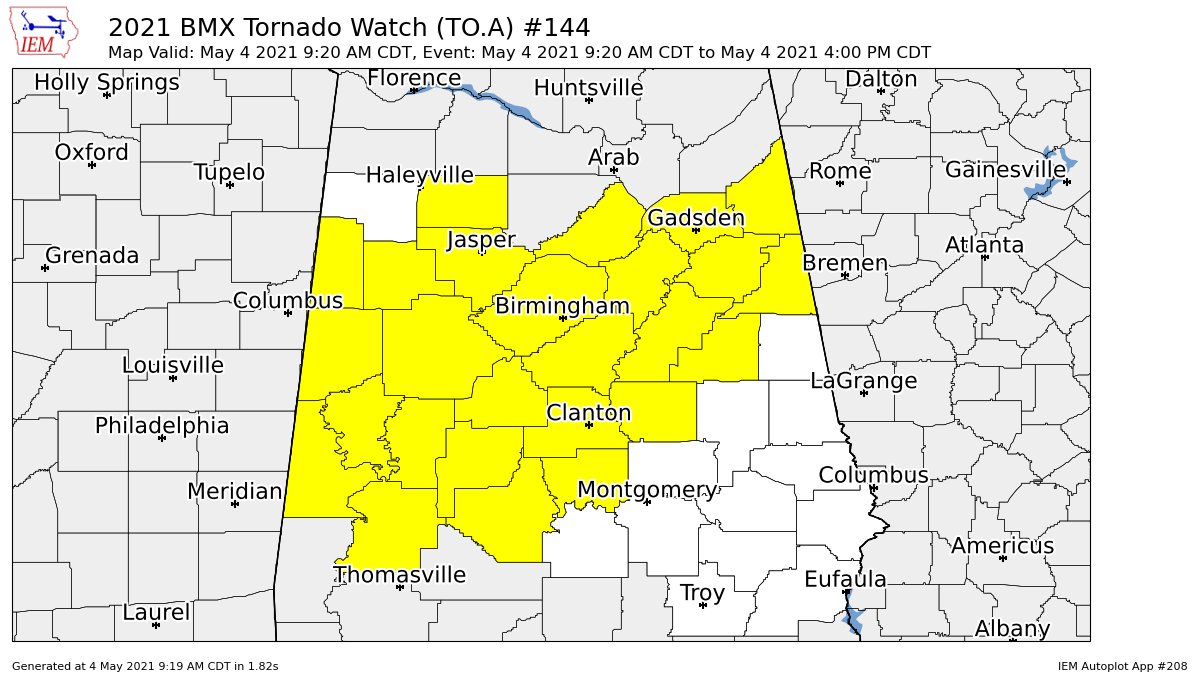
NWS Birmingham continues the Tornado Watch until 4 pm for the following counties in Central Alabama: Autauga, Bibb, Blount, Calhoun, Cherokee, Chilton, Clay, Cleburne, Coosa, Dallas, Etowah, Fayette, Greene, Hale, Jefferson, Lamar, Marengo, Perry, Pickens, Shelby, St. Clair, Sumter, Talladega, Tuscaloosa, Walker, Winston.
Here is the timing breakdown for the progression of the threat of severe storms across the area:
Now through 5 pm… northwestern corner of Central Alabama and western half of North Alabama.
Now through 7 pm… In and around the I-59 corridor from the northeastern corner of North Alabama to the southwestern corner of Central Alabama.
4 pm to 8 pm… South of the I-59 corridor to the I-85 corridor.
6 pm to 10 pm… Along and south of the I-85 corridor.
Category: Alabama's Weather, ALL POSTS, Severe Weather
"severe" - Google News
May 05, 2021 at 02:25AM
https://ift.tt/3b1QibO
A Quick Check of Our Severe Threat Just Before 2:30 pm - alabamawx.com
"severe" - Google News
https://ift.tt/2OrY17E
Shoes Man Tutorial
Pos News Update
Meme Update
Korean Entertainment News
Japan News Update
Bagikan Berita Ini


0 Response to "A Quick Check of Our Severe Threat Just Before 2:30 pm - alabamawx.com"
Post a Comment