
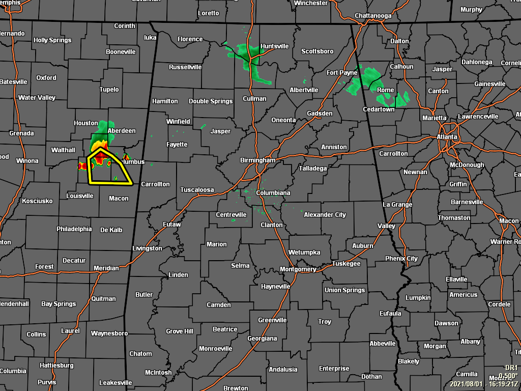
As of 11:19 am this morning, much of the shower and storm activity that began moving into the northern parts of the state has almost completely dissipated except for a few showers over the I-65 corridor from just south of Athens to Hartselle, along with a few showers just east of Fort Payne and northeast of Centre. Temperatures as of the 11 am roundup were in the upper 70s to the lower 90s across the area. Troy was the hot spot with mostly sunny skies at 92º. Haleyville was the cool spot with fair skies at 79º. Birmingham was at 84º with partly sunny skies.
While the activity has calmed down for the most part at this time, more showers and thunderstorms will fire up with this highly unstable and moist atmosphere, especially south of a cold front that is moving into the area. Rain will be likely by the afternoon hours across all the area, with afternoon highs maxing out in the upper 80s in the northwest to the upper 90s in the southeast. Some of these storms that develop with become strong to potentially severe.
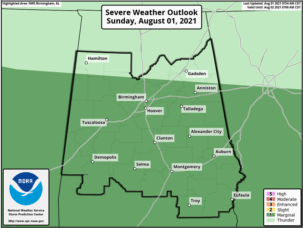
The Storm Prediction Center continues a level 1/5 Marginal Risk for severe storms for much of Central Alabama throughout the rest of today, including the cities of Anniston, Birmingham, Talladega, Hoover, Tuscaloosa, Alexander City, Clanton, Auburn, Demopolis, Selma, Montgomery, Eufaula, and Troy.
The main window for the threat of stronger to severe storms across the risk area will be from 1 pm this afternoon through 10 pm tonight. Damaging thunderstorm wind gusts up to 60 mph will be the severe threat with today’s storms. Localized flooding issues will be possible with the stronger storms, as there is plenty of moisture to work with over Central Alabama. All storms will have the potential for dangerous cloud-to-ground lightning. When storms approach your location, and you can hear thunder, you are close enough to the parent storm that you could be struck by lightning. Move indoors immediately.
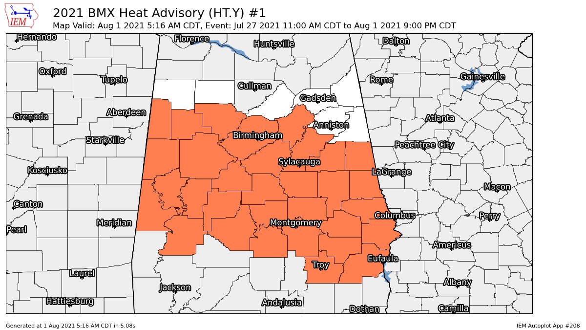
Not like we had enough to deal with already, much of Central Alabama remains under a Heat Advisory through 9 pm tonight, which includes the counties of Autauga, Barbour, Bibb, Bullock, Chambers, Chilton, Clay, Coosa, Dallas, Elmore, Fayette, Greene, Hale, Jefferson, Lamar, Lee, Lowndes, Macon, Marengo, Montgomery, Perry, Pickens, Pike, Randolph, Russell, Shelby, St. Clair, Sumter, Talladega, Tallapoosa, Tuscaloosa, and Walker.
Heat index values of up to 109º may occur before the cold front begins to move through the area and brings those temperatures down. Drink plenty of fluids, stay in an air-conditioned room, stay out of the sun, and check up on relatives and neighbors. Young children and pets should never be left unattended in vehicles under any circumstances.
For tonight, the shower and thunderstorm activity will continue before the coverage in storms will begin to diminish during the late-night and into the overnight hours. A few strong storms may occur with gusty winds, but severe weather is not expected after 10 pm tonight. Skies will remain cloudy after the rain ends, and overnight lows will fall into the upper 60s to the mid 70s across the area.
A cold front will continue to slowly push southward through the southern half of the area on Monday, that will keep shower and thunderstorm chances elevated for those locations. Only a few isolated to scattered showers and storms may be possible for the northern half. Highs will be in the 80s.
Category: Alabama's Weather, ALL POSTS, Severe Weather
"severe" - Google News
August 01, 2021 at 11:36PM
https://ift.tt/3lgol60
At Midday: Nearly All Quiet for Now, A Few Strong to Severe Storms Later Today - alabamawx.com
"severe" - Google News
https://ift.tt/2OrY17E
Shoes Man Tutorial
Pos News Update
Meme Update
Korean Entertainment News
Japan News Update
Bagikan Berita Ini


0 Response to "At Midday: Nearly All Quiet for Now, A Few Strong to Severe Storms Later Today - alabamawx.com"
Post a Comment