
(CNN)As we ring in the new year, severe storms and flooding will be hitting some of the same areas ravaged by tornadoes just two weeks ago, and some parts of the Midwest will be looking at their biggest snowstorm of the season so far.
"Both winter weather and severe weather possible to kick off the new year this weekend," the Weather Prediction Center (WPC) said in its forecast discussion.
As a cold front pushes its way into spring-like warmth all week over the southern states, it will help fuel strong to severe thunderstorms across the area.
"There is a moderate risk of excessive rainfall and an enhanced risk of severe thunderstorms over parts of the Ohio, Tennessee, and Lower Mississippi Valleys from Saturday into Sunday morning," the WPC also said.
The weekend is also forecast to start off with measurable snowfall and an icy wintry mix that are expected to cause widespread hazardous travel conditions on New Year's Day from the Central Plains to the Great Lakes.
Another round of severe storms
On the warm side of the front, ample moisture will help support storms capable of all severe weather hazards including large hail, damaging winds, flooding, frequent lightning, and tornadoes.
The Storm Prediction Center (SPC) cautioned even strong tornadoes will be possible Saturday and Saturday night.
The greatest areas at risk on Saturday will be from the Ark-La-Tex region through West Virginia.
The SPC says there'll be an enhanced risk of severe thunderstorms from Little Rock, Arkansas, to Birmingham, Alabama, and up to Lexington, Kentucky, Saturday into Sunday morning.

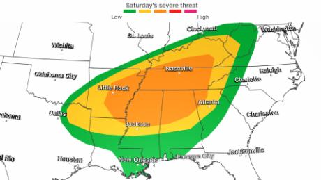
"The hazards associated with these thunderstorms are frequent lightning, severe thunderstorm wind gusts, hail, and a few tornadoes," the WPC said. "However, there is a 10% or greater probability of EF2-EF5 over parts of the Tennessee and Lower Mississippi Valley into parts of the Southeast."
Flooding will also be a major concern, especially across Kentucky, where cleanup is still ongoing from the tornadoes that ripped through the western part of the state nearly three weeks ago.
Flood watches are in effect from eastern Oklahoma all the way through West Virginia.
Widespread rain totals of 1-3 inches are expected from western Arkansas to western Pennsylvania. Kentucky could see the highest amounts, up to 4 inches through the weekend.
Given that the ground is already saturated across Arkansas, Kentucky, and Tennessee, flooding and flash flooding are very possible, forecasters said.
New year, new (colder) weather
After an incredibly warm December for much of the US, the new year may bring the first prolonged taste of winter for some states.
This could be the first significant snow event of the season for the Midwest, with widespread snowfall accumulations of 4 inches possible from eastern Kansas to Lake Michigan.
Heavier snow bands could result in even higher amounts of 6-8 inches or more along the Iowa/Missouri border and northern Illinois, resulting in widespread travel disruptions.
"Saturday morning, mountain ranges such as the Cascades, Sawtooth, Wasatch, and both the central and southern Rockies can expect 1 to 2 feet of snow with totals exceeding 3 feet in the highest elevations of Utah and Colorado," the WPC explained.
You can't have snow without cold, and there will be a major drop in temperatures this weekend.
Wind chill alerts are in effect for over half a dozen states across the northern Plains as subzero temperatures are forecast, with wind chills possible down to 45 degrees below zero.
"The dangerously cold wind chills could cause frostbite on exposed skin in as little as 10 minutes," the National Weather Service (NWS) said, referring to areas of Montana, Minnesota, Nebraska, and the Dakotas.
As the arctic air continues farther south and east it will bring plummeting temperatures to some cities that have not yet felt winter's chill.
Saturday, Memphis will go from highs around 70 degrees with thunderstorms down to highs in the mid 30s on Sunday, with some snow showers possibly mixed in.
The Dallas-Fort Worth area, which has set numerous high temperature records in the past two weeks, will also have high temperatures on Saturday in the low 70s, but by Sunday, high temps will drop to the upper 30s.
"The strong cold air advection behind this front will usher in the coldest temperatures of the season by far," the NWS office in Dallas/Ft. Worth said.
Did you say cold? Why not play some hockey? The Winter Classic outdoor game traditionally played on New Year's Day will be in Minneapolis this year, and it's going to be a cold one.
The high temperature on Saturday is only supposed to reach -2 degrees, but will be even colder when the game begins at 6 p.m. (7 p.m. ET) with a downright frozen temperature of -5 and a wind chill hovering around -20 degrees.
It could go down as the coldest outdoor NHL hockey game in history if those temperatures pan out.
"severe" - Google News
January 01, 2022 at 05:08PM
https://ift.tt/3EEedtO
2022 is starting with a flurry of severe weather - CNN
"severe" - Google News
https://ift.tt/2OrY17E
Shoes Man Tutorial
Pos News Update
Meme Update
Korean Entertainment News
Japan News Update
Bagikan Berita Ini


0 Response to "2022 is starting with a flurry of severe weather - CNN"
Post a Comment