
We’re on severe weather watch in the MPR Weather Lab through Wednesday.
Our steamy tropical air mass has all the ingredients to spawn severe storms across the Upper Midwest tonight and Wednesday.
Temperatures peak Wednesday in our overheated air mass with highs into the 90s once again.
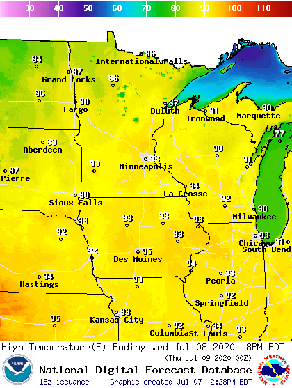
Forecast high temperatures Wednesday
NOAA
Dew points in the upper 60s to low 70s will provide fuel for storm cells to ascend rapidly, and generate heavy rains and large hail.
Two storm waves
It appears likely that two separate storm waves will cross the Upper Midwest tonight and Wednesday.
The first wave fires across western North Dakota tonight, then races east into the Red River Valley and northern Minnesota early Wednesday morning. The severe risk is highest in these areas through Wednesday morning.
Here's the Tuesday afternoon severe weather risk update from the Grand Forks NWS office.

Severe weather risk areas through Wednesday morning
Grand Forks NWS Office
NOAA’s NAM 3 km resolution model shows the likely storm evolution scenario between 10 pm tonight and 11 am Wednesday. A squall line may race into the Red River Valley in the wee hours Wednesday morning.

NOAA NAM 3 km resolution model 10 pm Tuesday to 11 am Wednesday
NOAA via tropical tidbits
Wave #2: Twin Cities late Wednesday
There may be a lull in storm activity during the midday hours Wednesday. Then the risk for severe storms shifts to central and eastern Minnesota Wednesday afternoon and evening.

Severe weather risk areas Wednesday
Twin Cities National Weather Service
One factor to note is the deep tropical moisture within the steamy air mass. Dew points in the 70s are likely across much of southern and central Minnesota ahead of the approaching low-pressure wave.

Dew point forecast for noon Wednesday
NOAA via tropical tidbits
As heat and humidity build and a weak low-pressure center approaches, the second wave of storms blows up in western Minnesota Wednesday afternoon. This wave has the potential to intensify and move through the Twin Cities area late Wednesday afternoon.
Forecast model storm timing may change by tomorrow, but right now many model favor a strong to severe line of storms blowing through the Twin Cities between 5 and 8 pm Wednesday.

NOAA NAM 3 km model 3 pm to 10 pm Wednesday
NOAA via tropical tidbits
Bow echoes?
This type of weather pattern favors the development of squall lines. On radar, these lines can surge and appear as bowing line segments, or bow echoes.

Bow echo evolution
NOAA
Bow echoes are notorious for damaging wind events. Wind can reach 70 mph or greater in many bow echo events. Large hail between 1 and 2 inches in diameter is also often generated by stronger storms.
Expect severe weather watches across North Dakota east into the Red River Valley and northern Minnesota Tuesday night into Wednesday morning.
Wednesday’s severe focus shifts to central and eastern Minnesota where watches and severe weather warnings look likely Wednesday afternoon and evening.
Stay situationally aware through Wednesday across the Upper Midwest.
"severe" - Google News
July 08, 2020 at 02:25AM
https://ift.tt/31UQZA0
Two severe storm waves likely in Minnesota Tuesday and Wednesday - Minnesota Public Radio News
"severe" - Google News
https://ift.tt/2OrY17E
Shoes Man Tutorial
Pos News Update
Meme Update
Korean Entertainment News
Japan News Update
Bagikan Berita Ini


0 Response to "Two severe storm waves likely in Minnesota Tuesday and Wednesday - Minnesota Public Radio News"
Post a Comment